Download Cairn Curran Reservoir guide
Things to do
Fishing
Late spring and early summer is best to find Golden Perch, Brown Trout, Murray Cod and Redfin at Cairn Curran.
Local anglers advise that using yabbies as bait on a running sinker can increase your chances of catching Redfin.
For the latest information on fishing in Victoria, contact Fisheries Victoria on 136 186, and don’t forget your Recreational Fishing Licence!
Camping
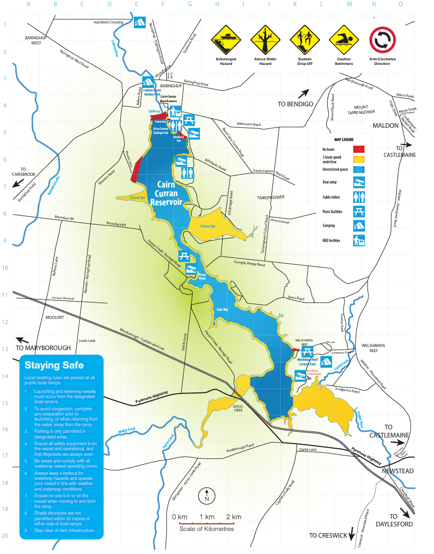
Camping at Cairn Curran Reservoir is only allowed in commercial caravan and holiday parks located around the water storage (see map).
Find out more about the parks
In addition to the parks there are plenty of B&Bs and holidays houses available year round. Visit the Maldon Castlemaine website for more information.
Boating
Cairn Curran is a popular spot for power boating, personal water craft, sailing, rowing and canoeing. The Cairn Curran Sailing Club holds regular events between October and April.
Vessels can be launched from public boat ramps around the reservoir (see map).
A 5 knot speed limit applies at any level within 50 metres of the water's edge; other vessels, navigation aids, swimmers and fixed or floating structures; and within 100 metres of vessels displaying a dive flag.
Keep a lookout at all times for hazards and other vessels.
Refer to the Victorian Recreational Boating Safety Handbook at the transport Victoria website.
Water levels
The water in Cairn Curran Reservoir is owned by GMW customers, who produce food and fibre, supply towns and businesses downstream of the storage, and protect and improve environmental waterway health.
Visitors need to be conscious of potential hazards and consider their own safety and the safety of other users at all times. Water levels (high or low) can prompt increased safety measures, and changes to access for recreational areas and boating. Safety information and alerts will be signposted at public areas and boat ramps.
Boating rules at Cairn Curran may change depending on water level.
- Level 1 (normal water levels) is above 28% capacity and normal boat zoning rules apply
- Level 2 (low water levels) is between 28% capacity and 13% capacity, and means those travelling above five knots are restricted to the waters at Tower Bay and south of a line of buoys running parallel to the main embankment
- Level 3 (very low water levels) is below 13% capacity, and this means the reservoir is closed to vessels operating at a speed above five knots.
Refer to the Guide to Vessel Operating and Zoning Rules for Victorian waters and current water level information.
Blue-Green algae
At times, the level of blue-green algae in storages can exceed safe limits. When this happens you should avoid direct contact with the water as the algae can cause;
- skin rashes
- itchiness
- sore eyes, ears and nose
- nausea.
If unsafe levels occur, warning signs will be positioned at major recreational areas.
Online Blue-green algae warnings are available or by calling the 24 hour GMW blue-green algae hotline on (03) 5826 3785.
About Cairn Curran Reservoir
Cairn Curran Reservoir is a key regional asset, located on the Loddon River directly south of Baringhup. It is surrounded by the historic gold mining towns of Maldon, Castlemaine and Maryborough. Completed in 1956, the reservoir has a capacity of 147,130 megalitres.
Today the reservoir supplies irrigation, stock and domestic, and environmental water to entitlement holders from surrounding towns and flows downstream into Laanecoorie Reservoir.
Located just two hours from Melbourne, Cairn Curran Reservoir offers plenty to see and do for the whole family. Enjoy a barbecue at one of the recreational reserves, launch a boat or throw in a line.
Cairn Curran is one of 23 lakes, dams and reservoirs managed by GMW to capture, store and deliver 70% of Victoria’s stored water across the region.
Facilities
Woolshed Bay, Spillway Reserve and Picnic Point Reserve are popular recreation spots, perfect for spending a day near the water. Woolshed Bay and Spillway Reserve offer toilet facilities and free-to-use barbecues. Public boat ramps can be found at Woolshed Bay and Picnic Point. Welshman’s Reef Caravan Park also has public toilet facilities and a boat ramp available to the public for a small launch fee.
Events
GMW’s lakes, dams and reservoirs are ideal places for events. Find out more about hosting an event at one of our storages.
Cairn Curran Reservoir code of conduct
Cairn Curran Reservoir is a beautiful and valued resource, both locally and regionally.
- camping and campfires are prohibited in GMW reserves and on foreshore and lakebed areas
- electric barbecues are available at some reserves (see map below)
- refer to your local council for landfill services and consider the environment when disposing of your litter. Penalties apply for illegal dumping of rubbish
- don’t take plants from the foreshore, or bring any in
- don’t feed the animals or wildlife, or interfere with their habitats
- boat wash can cause erosion, keep to 5 knots within 50 metres of the water’s edge
- vehicles and trail bikes are only allowed on public roads within the reserve
- all vehicles and trail bikes must be registered and users must be licenced
- keep the waterway healthy by not using soap, toothpaste or detergent in the lake
- dogs must be on a lead and/or under control at all times and aren’t allowed in the lake. Please clean up after your pets.
Review GMW’s recreational by-law
Staying safe
Local boating rules are posted at all public boat ramps.
- Launching and retrieving vessels must occur from the designated boat ramp/s.
- To avoid congestion, complete any preparation prior to launching, or when returning from the water, away from the ramp.
- Parking is only permitted in designated areas.
- Ensure all safety equipment is on the vessel and operational, and that lifejackets are always worn.
- Be aware and comply with all waterway vessel operating zones.
- Always keep a lookout for waterway hazards and operate your vessel in line with weather and waterway conditions.
- Ensure no one is in or on the vessel when moving to and from the ramp.
- Shade structures are not permitted within 50 metres of either side of boat ramps.
- Stay clear of dam infrastructure.
Facilities Map
Please Remember
- No campling or fires allowed on GMW foreshore land.
- Confine vehicles and motor bikes to formed public roads.
- Take your rubbish home.