DOWNLOAD Waranga Basin GUIDE
About Waranga Basin
The fourth largest inland waterway in Victoria, Waranga Basin is located between the Goulburn and Campaspe River basins, 8 km north-east of Rushworth and 12 km south-west of Tatura.
The basin was formed on the site of a natural wetland formerly known as Waranga or Gunn's Swamp. It is a family-friendly destination and one of the best kept secrets in Victoria.
Today the basin supplies irrigation and stock and domestic water to entitlement holders in the north and west of the state.
Waranga Basin is one of 23 lakes, dams and reservoirs managed by GMW to capture, store and deliver 70% of Victoria's stored water across the region.
Things to do
Fishing
Waranga Basin is a prime fishing spot where you can try your luck for Redfin, Murray Spiny Crayfish, Murray Cod, Trout and Golden Perch.
For the latest information on fishing in Victoria, contact Fisheries Victoria on 136 186, and don’t forget your Recreational Fishing Licence!
Camping
Camping is not allowed on the foreshore of the lake but there are a range of accommodation options through out the region.
Find out more on the Lake Waranga Caravan park website or the Parks Victoria website.
Boating
As one of the state's largest inland waterways tehre's plenty of space to play, so it's no surprise that boating is the most popular pastime for visitors.
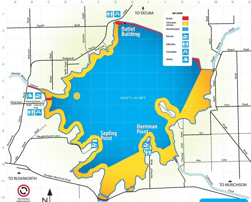
A 5 knot speed limit applies at any level within 50 metres of the water's edge; other vessels, navigation aids, swimmers and fixed or floating structures; and within 100 metres of vessels displaying a dive flag.
Keep a lookout at all times for hazards and other vessels.
Refer to the Victorian Recreational Boating Safety Handbook at the transport Victoria website.
Water levels
GMW's customers use the water in our storages to produce food and fibre, supply towns and businesses, and protect and improve waterway health.
Visitors need to be conscious of potential hazards and consider their own safety and the safety of other users at all times. Water levels (high or low) can prompt increased safety measures, and changes to access for recreational areas and boating.
Safety information and alerts will be signposted at public areas and boat ramps.
Find out more about current water level information.
Blue-Green algae
At times, the level of blue-green algae in storages can exceed safe limits. When this happens you should avoid direct contact with the water as the algae can cause;
- skin rashes
- itchiness
- sore eyes, ears and nose
- nausea.
If unsafe levels occur, warning signs will be positioned at major recreational areas.
Online Blue-green algae warnings are available or by calling the 24 hour GMW blue-green algae hotline on (03) 5826 3785.
Facilities
Facilities along the reservoir's foreshore include the popular Lake Waranga Caravan Park and Holiday Camp, picnic areas and public boat ramps.
You can explore the foreshore on one of the many trails where you're sure to find a secluded spot to sit and relax, or head out birdwatching kite flying or cycling. Waranga basin is also popular for boating and on-water activities.
Events
GMW’s lakes, dams and reservoirs are ideal places for events. Find out more about hosting an event at one of our storages.
Caring for Waranga Basin
Waranga Basin is a beautiful natural resource. You can help care for the lake so it can be enjoyed now and into the future.
- camping and campfires are prohibited in GMW reserves and on foreshore and lakebed areas
- electric barbecues are available at some reserves (see map below)
- refer to your local council for landfill services and consider the environment when disposing of your litter. Penalties apply for illegal dumping of rubbish
- don’t take plants from the foreshore, or bring any in
- don’t feed the animals or wildlife, or interfere with their habitats
- boat wash can cause erosion, keep to 5 knots within 50 metres of the water’s edge
- vehicles and trail bikes are only allowed on public roads within the reserve
- all vehicles and trail bikes must be registered and users must be licenced
- keep the waterway healthy by not using soap, toothpaste or detergent in the lake
- dogs must be on a lead and/or under control at all times and aren’t allowed in the lake. Please clean up after your pets.
Review GMW’s recreational by-law
Staying safe
Local boating rules are posted at all public boat ramps.
- Launching and retrieving vessels must occur from the designated boat ramp/s.
- To avoid congestion, complete any preparation prior to launching, or when returning from the water, away from the ramp.
- Parking is only permitted in designated areas.
- Ensure all safety equipment is on the vessel and operational, and that lifejackets are always worn.
- Be aware and comply with all waterway vessel operating zones.
- Always keep a lookout for waterway hazards and operate your vessel in line with weather and waterway conditions.
- Ensure no one is in or on the vessel when moving to and from the ramp.
- Shade structures are not permitted within 50 metres of either side of boat ramps.
- Stay clear of dam infrastructure.
Facilities Map
Please Remember
- No campling or fires allowed on GMW foreshore land.
- Confine vehicles and motor bikes to formed public roads.
- Take your rubbish home.